I'll post geographic information relevant here.
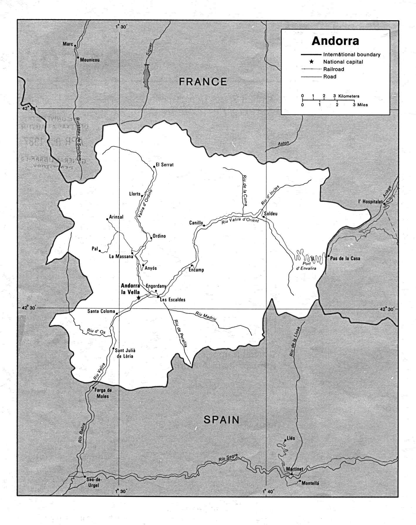
A useable map of Andorra with the major roads/routes depicted.
lib.utexas.edu/maps/europe/andorra.jpg
Or enter this address into Google Maps for the terrain:
+42° 30' 0.00", +1° 30' 0.00"
(centred on Andorra-la-Vella)
If you view this you'll get an idea of the "Y" shaped valley - there's very limited access wihtout the aid of flight or magic as we're talking high Pyrenees crest here.
Arans lies over halfway up the western arm of the "Y".
To the east of the valley, the main road from Andorra-la-Vella climbs through the Port d'Envalira through the town of Pas de la Casa (Pass of the House) and then follows the Ariege River from it's source down into the pro-Cathar County of Foix and thence on to Languedoc, still in the grip of the Albigensian Crusade in 1220.
The southern route leaves via the valley at the base of the "Y" through to the Catalan County of Urgell, whose bishop is the nominal feudal overlord of Andorra. The county of Urgell is currently claimed by the usurper Guerau de Cabrera, who has just seized it in 1220 from the rightful heiress, Aurembiax, sole daughter of the previous count Armengol VIII, on the death of her mother Elvira on the pretext that daughters cannot inherit.
This map from "A History of Aragon and Catalonia" via the LIBRO site (libro.uca.edu/chaytor/achistory.htm) puts Andorra into context with the surrounding Iberian and Occitanian territories and details the expansion of the Crown of Aragon over the next half-century:
libro.uca.edu/chaytor/1162.jpg
Cheers,
Lachie
Cheers! Cool maps 
The only thing to take into consideration is that the names in the Spanish side of the map are in Spanish, not Catalan. So, it is not "La Seo de Urgel" but "La Seu d'Urgell" et al. Apart from that, great map
As I see it, Arans is quite strategic, though. Being in the middle of the main route communicating Andorra La Vella with France to the north, so it is not out of the way of passage. Minor thingy, I know
Cheers,
Xavi
Thats if that road or town even existed back then, lol, it is hard to get exacting information about such an obscure subject. The original saga from way back when, the village was Andora la Vella because when I was a kid, didn't know there was more than one town in the whole place! There is some trade tansit going through Andorra, but it is not a major road or pass like Roncevalles is.
La seu d'urgell is one of the most important culture centres in Catalonia at the time IIRC, along with Ripoll. They are on the decline since the economicss and the frontier moved to the south, but they are important centres for sure.
The road is more difficult to assess, but given that it follows geography spot on (going along the valley et al) I would say that a medieval road (read: mud track) existed at the time.
Cheers,
Xavi
Polybus mentions Hannibal winning against the Andosini, so there must have been some way for him and his elephants to get there (about 218 BC).
Roads in Andorra were mainly built because of French trade with La Seu d'Urgell (the French sold military supplies), and pilgrimage to two sites "Canolic" (built later) and "Meritxell" (built before 1220). The valleys of Andorra were not connected by good roads during the reconquista (according to Siiner, Carsten, University of Freiburg). Canolic (in the Roman village St. Julia is based on a miracle from 1223 (see below).
Le Sanctuaire de Canòlic
Il est bâti à 1635 m d’altitude, se trouve à l’ouest de Sant Julia. Une vielle légende raconte qu’une vierge fut trouvée le 14 juillet 1223 par des habitants de la région, à qui elle révéla par des moyens surnaturels l’endroit où elle voulait que fut construit une chapelle pour la vénérer. L’église de Sant Cerni de Nagol. (cyberandorra.com/wiki/fr/and ... a-de-loria)
My translation: The sacred building of Canolic was built at an altutude of 1635 meters, west of St. Julia. An old legend tells of a virginthat was found July 14th 1223 by inhabitants of the region, which revealed by supernatural means (!) the place where she wanted them to build a chapel to venerate her, the church St. Cerni de Nagol.
In the late 12th century, on January 6, a wild rose in bloom was found by villagers from Meritxell going to Mass in Canillo. It was out of season and at its base was found a statue of the Virgin and Child.
The statue was placed in the Canillo church. However, the statue was found under the same wild rose the next day.
The statue was taken to the church of Encamp. However, as before, the statue was found under the same wild rose the next day.
As in similar legends elsewhere, the villagers of Meritxell took this as a sign and decided to build a new chapel in their town after they found an open space miraculously untouched by the winter snows. (en.wikipedia.org/wiki/Our_Lady_of_Meritxell)
From Sinner (and hints elsewhere), it can be assumed that a decent "road" for pilgrims led to Andorra's patron saint's statue.
Apart from the fact that Julià is Julian (masculine saint) and not Julia (feminine saint), I would say that the translation is spot on. I think it is "Julià " instead of Julia because IIRC in French it would be "Sainte Julia" if it was to be a feminine name.
Yeah, that is my pedantic streak showing his feathers here 

Might be wrong though, since my knowledge of French is extremely low (2 years in high school)
EDIT: Checked the catalan version of the website: Julià , male character
Cheers,
Xavi
The translation is accurate. Unless I'm drunk, drugged or very, very tired.
Great stuff JeanMichelle!
I like the Meritxell story - perhaps the virgin of Canolic will come up in play? I have an idea for an interesting companion that might tie into this neatly but I'll discuss it with Marko first.
Seems like the edit function has reappeared, so I'll tidy the first two posts up and perhaps add a few more links etc in along the way.
Cheers,
Lachie
The location on the map appears to contradict Mark's covenant information post that placed the covenant in the eastern Pyrenees and implied the coven was on the border of the Iberia and Provencal tribunals.
Mark, will this be changed to reflect the map or will there be another Andorra?
Err, no it doesn't...
Look at the Google Map coordinates if you're not convinced.
Andorra is definitely in the eastern half of the Pyrenees - not the easternmost tip of the Pyrenees (where the Col Perthus takes one arm of the old Roman road leading south from Narbonne along the coast), but definitely in the east. The source of the Ariege river lies just outside it's modern boundaries and in period runs down the next valley over to the east down into the Garonne which makes its way on to Toulouse.
Andorra definitely fits the bill for lying on the border of the Provencal and Iberian Tribunals.
Cheers,
Lachie
The following entry for Pass of Envalira[of Framiquel] in the Catalan Enciclopedia indicates that the road through Andorra is extant in period:
grec.cat/cgibin/hecangcl2.pg ... 8&PGMORI=E
It's probably a mud track rather than an asphalt highway and I'm not sure when the refuges were first inhabited.
Cheers,
Lachie
Maybe I should consider calling my giant ancestor Valira, now that you mention it. Pass d'en Valira (I guess that would be original writing) mean Pass of Valira, Valira being a personal name.
Refuge of Framiquel means the refuge of Friar Miquel. There we have a potential confrontation between magic (or faerie) and divine powers, I would say.
Xavi
Is this true in the laws of the region at that time, or was it usual to have the daughter marry into another family and bring the title/land with her? i.e. Is this really a 'pretext'? Or, even if a daughter doesn't inherit and then give the title to her husband at this time, if she really can't inherit... wouldn't the title revert to the crown? What 'should' have happened other than what did happen?
And do we know what happened to Aurembiax? Is she still running around out there somewhere trying to get her land back? ![]() Perhaps a story in the offing?
Perhaps a story in the offing?
Yes, daughters would inherit land and marrigaes to cement treaties and land deals were common. And, from what I have read, femal nobility was not as powerless as one may imagine. They appeal to their fathers a lot, and I am reminded of bold (and trecherous) queens such as Urrica.
There was an inordinate number of illegitimate children amonst Spanish monarchs though, and they also inherited and were part of marriage treaties.
Marko is correct.
There's a bit of difference between Castile-Leon-Galicia vs Catalonia (which tended to be more feudal and linked to the Languedoc region). Male primogeniture was more common in the west, but in regions previosuly dominated by Basque tribes eg Navarre and Aragon/Ribacorga/Sobrabre there was female inheritance documented.
Female nobility in particular endowed convents, monasteries etc.
Feudalism was much less developed in Spain, even in Catalonia although once the borders started marching south there was "crown land" which was apportioned by monarchs. Many of the older northern Spanish holdings were allods (free-title) but this is becoming rarer by the time of the 13th century as the kings use the Reconquista to shore up their feudal power.
Aurembiax is a bit of a shadowy figure from 1213 (just after her marriage) and Guerau has only just wrested control on the death of her mother, Elvira in 1220 - perhaps she is still around and will try to appeal to the covenant for aid. Perhaps she is already disguised as one of the covenfolk or has agents in the covenant, unbeknownst to the magi...
en.wikipedia.org/wiki/Ermengol_VIII_of_Urgell
en.wikipedia.org/wiki/Aurembiaix_of_Urgell
en.wikipedia.org/wiki/Guerau_IV_of_Cabrera
Cheers,
Lachie
Some cool links and maps
newworldencyclopedia.org/entry/Andorra
newworldencyclopedia.org/ent ... rramap.png
newworldencyclopedia.org/ent ... Andora.png
newworldencyclopedia.org/ent ... ella06.jpg
newworldencyclopedia.org/ent ... _vella.jpg
newworldencyclopedia.org/ent ... ndorra.jpg
Thanks!
Linked it in the wiki, and used the map 
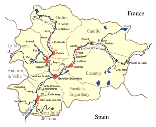
Here is a bunch of map material I resources off of Fixer's Andorra wiki. Do note that said wiki is old and out of date. I myself didn't update it much and Fixer was kind enough to make it in the first place so I never bugged him about it.
I would like to make these full display maps posted right here instead of posting a link, but I don't know how to do that. Though I use the damn machine all the time, I am sorta retarded when it comes to computer black magic.
andorra.wikidot.com/local--files ... rramap.png
andorra.wikidot.com/local--resiz ... medium.jpg
andorra.wikidot.com/local--resiz ... medium.jpg
And the castle
andorra.wikidot.com/local--resiz ... medium.jpg
And yes, I realize the castle map is from the old D&D module "Keep on the Borderlands". It is nostalgia to me, dating back to 7th grade in 1982. It is the map I have always used to represent this covenant. Pay no attention to the numbered key and little bs. This is just vaguely what the covenant keep looks like.
And I have rediscovered many juicy tidbits in this thread posted years ago. And since now my knowledge of Andorra is much more expanded then it was then, I can see how to easilly incorporate some of that stuff. If desired.
